Chasing Tides and Temperatures: Pre-Workshop Fieldwork Along the South African Coast
- fevaldovinos

- Apr 30
- 3 min read
Updated: May 1
Before convening in the seminar rooms of Stellenbosch University for the International Workshop on Food Web Dynamics, our international team of researchers hit the rugged South African coastline. From December 4th to 7th, 2025, researchers from Portugal, South Africa, and the US embarked on an intensive, multi-stop fieldwork expedition to collect critical environmental data and deploy specialized temperature loggers across some of the world's most iconic capes.
Here is a look at our journey along the edge of the continent, where the Atlantic and Indian Oceans meet.
The Mission: Capturing the Intertidal Microclimate
A core objective of this coastal road trip was managing the sensor network managed by Fernando Lima and Rui Seabra’s team from Portugal. But what exactly does "deploying loggers" entail?
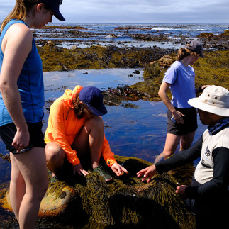
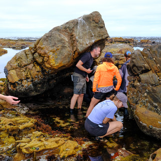
In marine ecophysiology, simply measuring the water or air temperature isn't enough to understand what a mussel, barnacle, or limpet actually experiences. Lima's group specializes in deploying biomimetic temperature loggers—tiny, autonomous sensors often embedded in epoxy resin designed to mimic the exact size, shape, and thermal properties of intertidal organisms (like "robomussels" or "robolimpets").
Deploying these loggers involves trekking out into the rocky intertidal and supratidal zones during low tide, drilling or epoxying these sensors directly onto the rock face, and retrieving data from previously deployed loggers. These devices record high-resolution, long-term microclimate data, revealing the extreme thermal stress these vulnerable ecosystems face during low-tide sun exposure and high-tide submersion.
The Itinerary: Four Days, Four Iconic Shores
Day 1: December 4 – Hitting the Ground Running in Paternoster
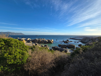
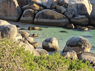
The fieldwork began the moment flights touched down in Cape Town. After picking up team members (including Rui, Cátia, Mark, and Fernando), the crew drove two hours north to the coastal village of Paternoster. Racing against the mid-tide at 6:00 PM, the team successfully downloaded historical data from existing sites and deployed a new batch of supratidal loggers. The day ended with a three-hour drive south to Simon’s Town, where the advance team met up with the rest of the researchers (and penguins!) at Boulders Beach.


Day 2: December 5 – The Cape of Good Hope
With an early low tide at 9:15 AM, the team set out for the Cape of Good Hope. This site held special sentimental value for the Portuguese researchers, given its monumental historical significance to Portuguese explorers. Working right at the edge of the famous cape, the team serviced the rocky shore sites before packing up for a nearly four-hour drive east to Struisbaai to rest at Land’s Edge Cottages.


Day 3: December 6 – The Southernmost Tip of Africa
The target for Saturday was Cape Agulhas, the true geographic southern tip of the African continent and the official dividing line between the Atlantic and Indian Oceans. Taking advantage of the 10:00 AM low tide, the team worked the excellent, layered rocky shores directly in front of the iconic landmark. Following a successful morning in the intertidal zone, the convoy continued three hours east to Mossel Bay.
Day 4: December 7 – The Waves of Cape St Blaize
The final day of fieldwork took place at Mossel Bay Point, near the Cape St Blaize lighthouse. Known for its beautiful east-west layered rocks, this site is ideal for intertidal research, though it presents challenges with heavy wave action and high foot traffic. After wrapping up the final logger deployments and data collections during the 11:10 AM low tide, the team loaded up the vehicles for the five-hour return journey to Cape Town.
From the Shore to the Seminar Room
By Sunday evening, the fieldwork was complete. The data retrieved from these remarkably productive and thermally dynamic rocky shores—spanning from Paternoster to Mossel Bay—will feed directly into the models discussed during the subsequent week's workshop. By connecting this hard-earned, on-the-ground microclimate data to global climate models, the team is taking vital steps toward predicting the future of our oceans' most critical ecosystems.


Comments